Hydrologic Investigations Atlases

Hydrologic Investigations Atlases (HA) The United States Geological Survey's (USGS) hydrologic investigations atlases listed below pertain to Nebraska. Some of the titles have been prepared cooperatively by the USGS and the Conservation and Survey Division.
-
Availability of Ground Water in Hall County, Nebraska (HA-131)
$7.00 -
Flood of August 1966 in the Lower Loup River Basin, Nebraska (HA-188)
$7.00 -
Geohydrology of Saline County, Nebraska (HA-216)
$7.00 -
General Availability of Ground Water and Depth to Water Level in the Missouri River Basin (HA-217)
$7.00 -
Floods in Seward Quadrangle, Southeastern Nebraska (HA-258)
$7.00 -
Availability of Water in Eastern Saunders County, Nebraska (HA-266)
$7.00 -
Availability of Ground Water in Adams County, Nebraska (HA-287)
$7.00 -
Water Resources of Antelope County, Nebraska (HA-316)
$7.00 -
Flood of June 1967 at Grand Island, Nebraska (HA-352)
$7.00 -
Ground Water in Polk County, Nebraska (HA-389)
$7.00 -
Floods in the Vicinity of Crete, Nebraska (HA-503)
$7.00 -
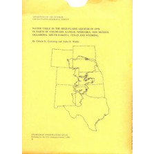
Water Table in the High Plains Aquifer in 1978 in Parts of Colorado, Kansas, Nebraska, New Mexico, Oklahoma, South Dakota, Texas and Wyoming (HA-642)
$7.00