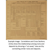
Correlations and Cross Sections
Correlations and Cross Sections (CCSs) show the relationships among rocks and deposits by showing a "cut-away" view and by connecting similar rocks and deposits. Most are print-on-demand, allow additional time for processing.
-

Block Diagram-Bedrock Geology of Nebraska (CCS-2)
$25.00 -

W-E Electric Log Chart of Jurassic and Cretaceous Systems from Western Nebraska (Cheyenne, Deuel, Keith and Kimball counties) (CCS-6)
$25.00 -
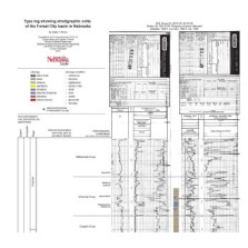
Type log and stratigraphic units of the Forest City basin in Nebraska Correlations and Cross Sections (CCS-19)
$25.00 -
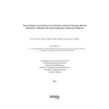
Three Geologic Cross Sections Across Portions of Eastern Nebraska Showing Quaternary Lithologic Units and Stratigraphy of Uppermost Bedrock (CCS-18)
$0.00 -

Stratigraphic Cross Section of Paleozoic Rocks (Oklahoma to Saskatchewan) (CCS-15)
$15.00 -

Profiles of Datum Horizons "b" to "m" Along the 104-Degree Meridian, Western Nebraska (Upper Cretaceous to Recent) (CCS-10)
$15.00 -

Electric Log Correlation and Subsurface-Surface Relations of White River Group in Scotts Bluff County, Nebraska (CCS-7)
$25.00 -

Profiles of Datum Horizons "a" to "m" Along the 103-Degree, 30-Minute Meridian, Western Nebraska (Upper Cretaceous to Recent) (CCS-9)
$15.00 -

N-S Electric Log Chart of Jurassic and Cretaceous Systems from Western Nebraska (Cheyenne to Dawes Counties) (CCS-4)
$25.00 -

N-S Cross Section of Cambrian Through Cretaceous from Knox to Webster Counties (CCS-13)
$15.00 -
Electric Log Cross-Section of Upper Cretaceous to Recent Along the 103-Degree, 30-Minute Meridian, Western Nebraska (CCS-8)
$25.00 -

NE-SW Electric Log Chart of Jurassic and Cretaceous Systems in Garden and Cheyenne Counties, Western Nebraska (CCS-5)
$25.00